For international readers: This article is based on the original Japanese version, but it has been localized rather than translated word for word. Short explanations of Japan-specific hiking terms, mountain access, and local travel context have been added so that readers outside Japan can better understand what makes Tsuboniwa an accessible—but still genuinely alpine—place to visit.
This post contains affiliate links.
In Short: Step Off the Ropeway at 2,237 m
The Kitayatsugatake Ropeway connects the base station at 1,771 m with the summit station at 2,237 m (7,339 ft) in about seven minutes.
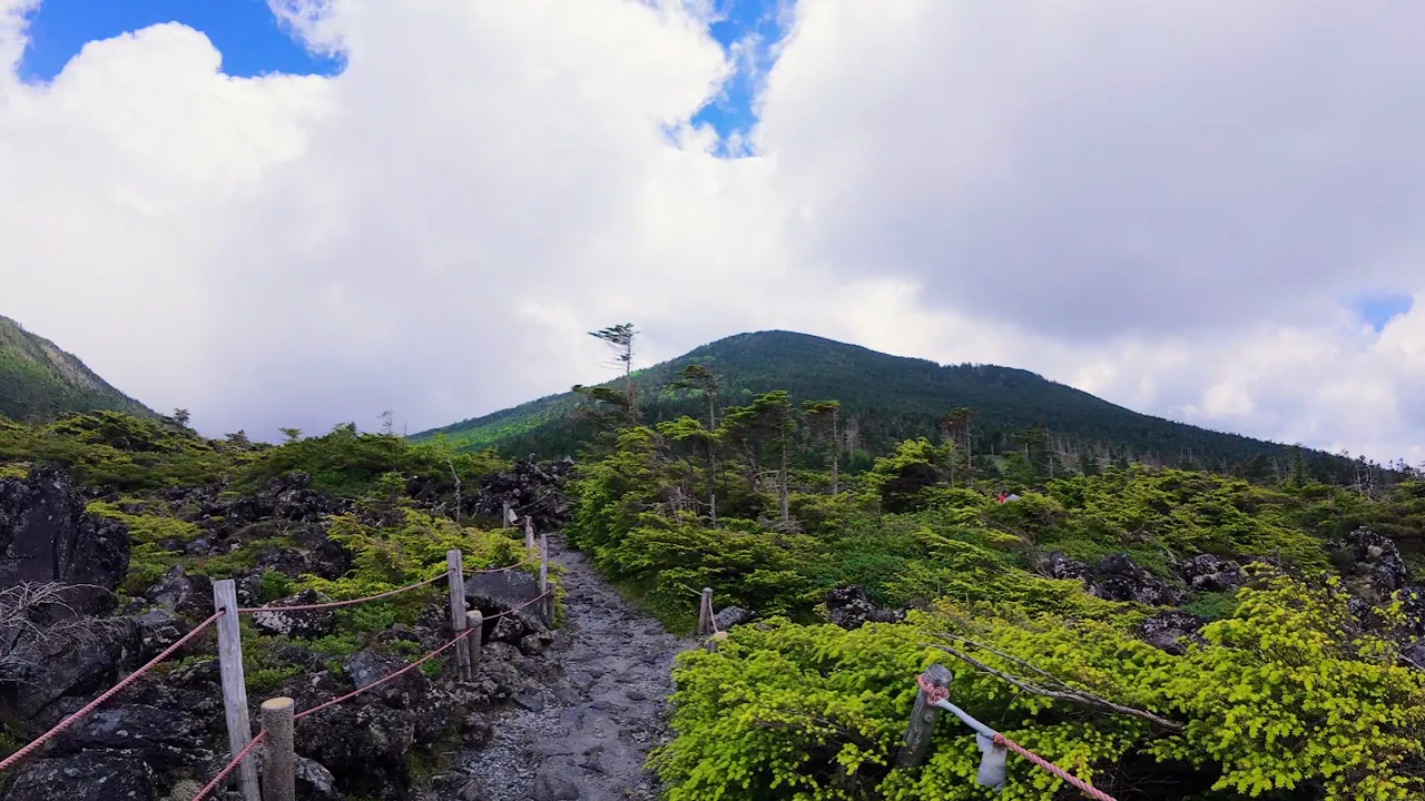
Step outside the summit station and you will not find a gentle grassy plateau. Instead, Tsuboniwa Nature Park spreads out in front of you: a natural volcanic lava plateau where dark rock and low-growing trees create a stark, distinctly Northern Yatsugatake landscape. Without a long climb, you can experience the air and scenery of the subalpine zone above 2,200 m.
The Tsuboniwa loop takes about 30–40 minutes, but this is not a flat park promenade. The route includes gravel, boardwalks, rocky steps, and some fairly steep stairs. Think of it as a short mountain walk rather than ordinary sightseeing.
In this article, I treat the Tsuboniwa loop as a form of casual, ropeway-assisted hiking. If you continue toward Mt. Kitayokodake or Mt. Shimagare, you leave the sightseeing trail and enter a proper mountain route that requires hiking equipment and a hiking plan.

The Kitayatsugatake Ropeway summit station seen from Tsuboniwa. Step off the ropeway and Tsuboniwa Nature Park opens up at 2,237 m (photo by the author, 2026).
Basic Information
| Item | Details |
|---|---|
| Location | Kitayatsugatake Ropeway, Chino, Nagano Prefecture |
| Base station elevation | 1,771 m |
| Summit station elevation | 2,237 m (7,339 ft) |
| Ropeway ride | About 7 minutes |
| Tsuboniwa loop | About 30–40 minutes |
| Trail surface | Gravel, boardwalks, stairs, and rocky steps |
| Best season for alpine flowers | Around mid-June to mid-August |
| Autumn colors at Tsuboniwa | Around late September |
| Parking | About 600 spaces, free of charge |
| Toilets and shops | Available around both the base and summit stations |
| Busiest periods | Summer holidays, autumn foliage season, long weekends, and weekends |
Operating hours, fares, and seasonal closures can change, so check the official Kitayatsugatake Ropeway website before your visit.
What the Tsuboniwa Loop Is Like
Tsuboniwa Nature Park has a loop trail beginning and ending at the ropeway summit station.
The standard walking time is about 30–40 minutes. If you want to stop for photographs, alpine plants, and views, allow roughly one to one and a half hours for your stay around the summit station.
| Route | Approx. time | What to expect | Footwear |
|---|---|---|---|
| Summit station and observation area | 15–30 min | Enjoy the views and stay close to the station | Comfortable walking shoes |
| Tsuboniwa loop | 30–40 min | Walk through the lava plateau and look for alpine plants | Grippy sneakers or better |
| Toward Mt. Kitayokodake | 2+ hr round trip | Follow a mountain trail to the summit | Hiking boots and hiking gear |
| Toward Mt. Shimagare | Several hours | Forest and mountain trails | Hiking boots and hiking gear |
The Tsuboniwa loop is where the casual walk ends. Continue toward Mt. Kitayokodake or Mt. Shimagare and you leave the sightseeing trail for a mountain hiking route.
Why Is Tsuboniwa So Rocky?

Low shrubs taking root among the dark volcanic rocks of Tsuboniwa (photo by the author, 2026).
Tsuboniwa is a lava plateau formed by volcanic activity from Mt. Kitayokodake. Over a long period, plants gradually colonized the exposed rock and created the landscape you see today.
The name Tsuboniwa may sound like a small, carefully arranged Japanese garden. In reality, this is not a garden designed by people. It is a natural garden shaped by lava, wind, snow, and plants.
Among the dark rocks, Japanese stone pine, northern Japanese hemlock, and other trees grow low to the ground. Because vegetation does not cover the entire surface like a meadow, you can clearly see plants gradually spreading through gaps in the rock.
At nearby Ikenotaira Wetland, the distinctive sight is komakusa growing in gravelly alpine habitat. At Tsuboniwa, the attraction is different: watching plant life find its way into an overwhelmingly rocky landscape.
Don’t Expect a Flower Meadow—Look Between the Lava Rocks
According to the Kitayatsugatake Ropeway, alpine flowers are generally at their best from mid-June to mid-August, with the greatest variety typically appearing from late June to early July.
This is not like the broad colonies of daylilies at Yashima Wetland. At Tsuboniwa, the fun is in looking closely for small flowers growing in cracks in the lava and at the feet of low shrubs.
When I visited, the ko-iwakagami season had already ended, while lingonberry and bunchberry were in bloom. Flowering times vary from year to year, so the official flower calendar is worth checking before your visit.

Alpine plants flowering between the lava rocks: wild strawberry, bunchberry, and lingonberry (photo by the author, 2026).
Tsuboniwa lies within a highly protected zone of Yatsugatake-Chushin Kogen Quasi-National Park. Stay on the designated trail, and leave plants and rocks where you find them.
How to Walk the Tsuboniwa Loop
Check Your Extra Layer and the Return Ropeway Time
The ropeway gains 466 m in elevation in only a few minutes, so the air at the summit station can feel noticeably cooler than at the base. Before heading outside, take out an extra layer, use the restroom, and check the return ropeway schedule.
You cannot make a round trip on the final departure. Weather can also cause schedule changes or service suspensions, so be particularly careful if you start walking later in the day.
Take the First Stairs Slowly
The Tsuboniwa trail includes some fairly steep stairs.
At 2,237 m, you may become short of breath more easily than at low elevation, especially just after stepping off the ropeway when your body has had little time to adjust to the change in temperature and altitude. There is no need to rush the first staircase—take it slowly and enjoy the view.
Choose Shoes That Work on Gravel, Boardwalks, and Rock
Dry gravel can shift underfoot, while boardwalks and rocks become slippery after rain.
You can walk the loop in comfortable sneakers, but worn shoes with flat soles, sandals, and heels are poor choices. Sneakers with a treaded sole or hiking shoes will be more comfortable and secure.
Be Ready for the Climate at 2,237 m
Even in midsummer, temperatures around the summit station can be around 20°C (68°F), and mornings or evenings may fall to around 10°C (50°F). Even when temperatures at the foot of the mountain exceed 30°C (86°F), wind at the summit can make a single short-sleeved shirt feel cold.
Bring a light wind shell or long-sleeved layer in summer, as well as rainwear.
Thunderstorms and Strong Winds
In the Japanese summer mountains, a clear morning can turn into developing clouds, thunderstorms, and strong winds later in the day.
Tsuboniwa makes it relatively easy to return to the summit station, but do not wait until you hear thunder before heading back. If clouds begin building or the wind suddenly turns colder, return early. The ropeway may also change or suspend service because of strong winds or lightning, so check current operations and the summit live camera before setting out.
If You Feel Unwell, Do Not Continue Higher
A rapid gain in elevation can leave you more short of breath than usual, and some people may experience symptoms such as headache or nausea.
If something feels wrong, rest near the summit station. If you do not improve, take the ropeway back down. Most importantly, do not continue toward Mt. Kitayokodake while feeling unwell.
Clothing and What to Bring
| Category | Recommendation |
|---|---|
| Shoes | Grippy sneakers; hiking shoes are preferable |
| Extra layer | A light wind shell or long-sleeved layer even in summer |
| Rain protection | Rainwear |
| Sun protection | Hat, sunscreen, sunglasses |
| Water | Bring some even for a short walk |
| Bag | Small daypack that keeps both hands free |
| Before departure | Check ropeway operations, summit weather, and final departure time |
You do not need a full-size hiking backpack just for the Tsuboniwa loop. Because there are stairs and rocky steps, a small daypack is more practical than a hand-carried bag.
Purchases made through these links help support the operation of this blog.
From a Casual Walk to a Mountain Hike: Mt. Kitayokodake
The trail from Tsuboniwa to Mt. Kitayokodake is the standard route for hikers using the ropeway to reach the mountain.
From the summit station to the summit of Mt. Kitayokodake, the elevation gain is about 240 m, with a typical round-trip time of around two hours.1 The distance is fairly short, but the route follows a mountain trail with rocks and exposed tree roots before reaching the 2,480 m summit.
If you plan to climb Mt. Kitayokodake, treat it as a separate hike rather than an extension of sightseeing at Tsuboniwa. Bring hiking boots, warm layers, rainwear, a map, and trail food, and allow enough time for passing other hikers and taking breaks so that you return well before the final ropeway. Ice or lingering snow may also remain in spring and autumn.
The standard round trip between the ropeway summit station and Mt. Kitayokodake is not representative of every route in the area. Difficulty changes significantly once you continue elsewhere around the mountain. The route toward Mitsudake crosses a rugged rocky ridge with large boulders. The route toward Odake is awkward underfoot, with huge rocks piled across the trail. Routes toward Kikkoike and Futagoike include steep sections and long loops.
Do not continue beyond the summit of Mt. Kitayokodake simply because it looks like a short extension on the map. Any loop or traverse that does not return directly to the ropeway station should be planned with a map, current trail information, sufficient hiking experience, and enough time.
Access and Parking
The Kitayatsugatake Ropeway base station is about a 40–50 minute drive from the Suwa Interchange on the Chuo Expressway. There is free parking for about 600 vehicles.
During summer holidays, autumn foliage season, and long weekends, both the ropeway queue and nearby roads can become crowded. Arriving close to opening time is often more comfortable. Opening times vary by season, so check the official information for the day of your visit.
By public transport, take a local bus from JR Chino Station—the main rail gateway for this area—to the Kitayatsugatake Ropeway. Bus schedules are seasonal, so check the Alpico Kotsu timetable in advance.
This article covers the snow-free season. In winter, the access roads can be snowy or icy and Tsuboniwa becomes a winter mountain environment. The equipment required is completely different.
Nearby Places That Pair Well with Tsuboniwa
Even with a relaxed stay at the summit station, the Tsuboniwa loop usually fits easily into half a day, making it easy to combine with a drive around the Tateshina Highlands or a hot-spring stop.
Lake Tateshina and Roadside Station ‘Venus Line Tateshina-ko’
These are convenient places to stop on the way back toward central Chino after your walk. A michi-no-eki is a Japanese roadside station that typically provides parking, toilets, and local shops or food.
Lake Shirakaba and the Kurumayama Area
If you have enough time and the weather is good, you can continue via the Venus Line, a scenic highland driving route, toward Lake Shirakaba and Kurumayama. Traffic can be heavy during summer holidays and autumn foliage season, so it is usually more enjoyable not to pack too much into one day.
Day-Use Onsen
There are many day-use onsen—public hot-spring baths—between the Tateshina Highlands and the Chino/Suwa area. Even this short walk uses your legs on the stairs, so a hot-spring stop can also make a pleasant break before the drive home.
FAQ
Can I Walk Tsuboniwa in Sneakers?
Yes. Comfortable sneakers are enough for the loop, but the route includes gravel, boardwalks, stairs, and rocky steps. Choose shoes with good grip and a treaded sole.
How Long Does the Tsuboniwa Loop Take?
The official estimate is about 30–40 minutes. If you want time for photographs and plant watching, allow roughly one to one and a half hours for your overall stay around the summit station.
Is Tsuboniwa Suitable for Children?
Children who are comfortable with stairs and uneven steps can enjoy the route. This is not a completely level, paved park, so keep a close eye on small children.
Can I Complete the Loop with a Stroller or Wheelchair?
No. The loop includes gravel, dirt, and stairs. According to the official website, wheelchair access is available in summer as far as the observation area connected to the summit station.
Is Tsuboniwa Worth Visiting in the Rain?
The lava plateau can look atmospheric in fog, but boardwalks, rocks, and stairs become slippery. If thunderstorms or strong winds are forecast, skip the walk and check the ropeway operating information.
Summary
Tsuboniwa at the Kitayatsugatake Ropeway lets you enter the subalpine zone at 2,237 m without a long climb and observe both a volcanic lava plateau and alpine plants.
Unlike the grasslands and daylilies of Yashima Wetland or the gravelly habitat and komakusa of Ikenotaira Wetland, the defining sight at Tsuboniwa is plant life spreading through gaps in dark volcanic rock.
- The ropeway ride takes about 7 minutes, and the Tsuboniwa loop about 30–40 minutes.
- The trail includes gravel, boardwalks, stairs, and rocky steps.
- Bring an extra layer and rainwear even in summer.
- Look for alpine plants in the gaps between the lava rocks rather than expecting a flower meadow.
- Routes toward Mt. Kitayokodake are mountain hikes, not part of the Tsuboniwa sightseeing loop.
- Many routes beyond the summit of Mt. Kitayokodake are substantially rougher and more demanding.
The ropeway makes reaching this altitude easy. That is exactly why it is worth preparing for the mountain climate and uneven ground before you start walking.
Casual-Hike Check
For a snow-free-season loop of Tsuboniwa from the Kitayatsugatake Ropeway summit station.
| Item | Assessment |
|---|---|
| Walking time | 30–40 min; allow 1+ hr with photography and breaks |
| Elevation change | Includes stairs |
| Trail surface | Gravel, boardwalks, rocks, stairs |
| Clothing | Carry a wind-resistant layer and rainwear even in summer |
| Car access | Large free parking lot |
| Beginner-friendly | Yes, but remember that you are at 2,237 m |
| Boundary with hiking | Routes toward Mt. Kitayokodake and Mt. Shimagare are regular mountain hikes |
Update History
- 2026/07/30 Added a YouTube Short to the “How to Walk the Tsuboniwa Loop” section.
Approximate hiking time based on Yamareco, a widely used Japanese hiking route and activity-log service. ↩︎